Our programme aim is to advance our understanding of, and capability to predict, the Southern Ocean’s impact on climate change via its uptake and storage of heat and carbon.
ORCHESTRA will significantly reduce current uncertainties concerning how the uptake and storage of heat and carbon by the ocean influences global climate, by conducting a series of unique fieldwork campaigns and innovative model developments. This is a leading-order challenge of great societal relevance and strategic importance to NERC, but progress is currently hampered by poor provision of data with which to improve understanding of the key processes and constrain their rates, and inadequate representation of the key dynamics in ocean and climate forecast models.
The area requiring the most urgent improvement is the Southern Ocean, where many of the controlling mechanisms and exchanges occur, and yet where data coverage is most sparse, dynamical understanding is weakest, and climate models show greatest biases and least realistic depictions of processes.
ORCHESTRA will address these issues using the UK’s world-leading capability and infrastructure in ocean and high-latitude research, including major ship expeditions, autonomous vehicle deployments and research aircraft campaigns, with the data collected used to improve model schemes and validate model outputs, and with the improved capability fed through to UK climate model development.
ORCHESTRA represents the first fully-unified activity by NERC institutes to address these challenges, and will draw in national and international partners to provide community coherence, and to build a legacy in knowledge and capability that will transcend the timescale of the programme itself.
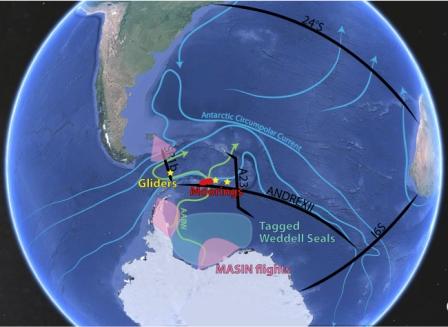
Schematic of the ORCHESTRA fieldwork. Black lines are major ship-based expeditions; pink sectors are flying areas for the BAS meteorological aircraft; red ellipse denotes a deep-ocean mooring cluster; green splodge is the region to be covered by instrumented seals; yellow stars are nominal areas of deployment for autonomous ocean vehicles. The entire region will also have data coverage from profiling floats and satellite measurements.

Recent posts